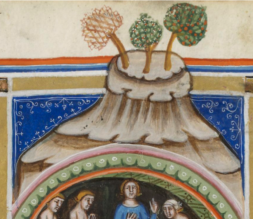
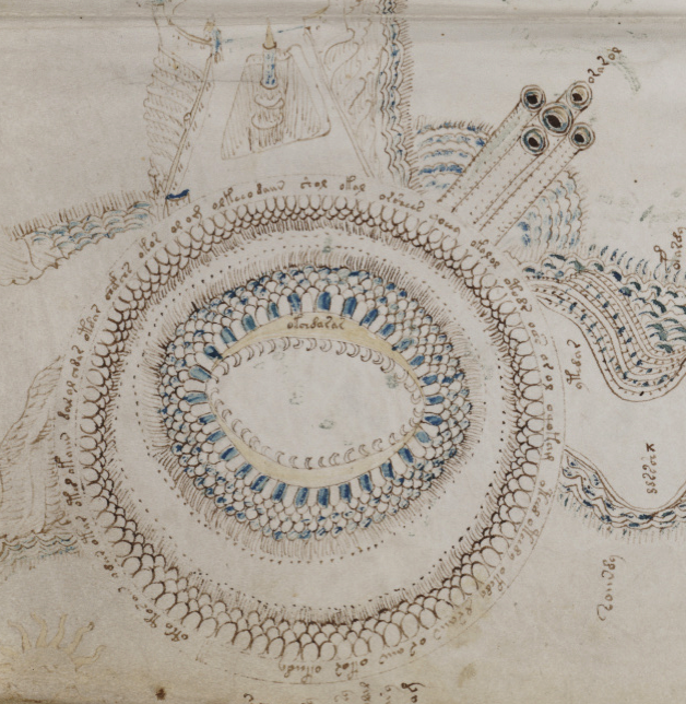
The upper-left rotum in the VMS “map” is often called a “volcano”—a handy term that most people intuitively comprehend even if we don’t know what the drawing represents.
Volcanic eruptions have long been memorialized in drawings and chronicles, including a Pseudo-Dionysius description from the 6th century:
Such was the violent and harsh disaster, which was sent from heaven, that fire alight and consumed those who had escaped from the terrible vehemence of the cataclysm of the earthquake and the collapse: the sparks flew and set fire to everything on which they settled. The earth itself from below, from within the soil, surged, seethed and burned everything which was there. Thus the foundations as well, together with all the storeys above them, were lifted up, heaved up and down and burst apart, collapsed, fell and burned with fire… In the end no house or church or building of any kind remained, not even the garden fences, which had not been torn asunder or damaged, or had not disintegrated and fallen. The rest burned, crumbled away and became like an extended putrefaction.
It’s possible volcanic eruptions were depicted in ancient cave paintings, but this particular cataclysm was not especially common in medieval art, which makes it difficult to identify illustrative traditions.
This clip is from a 1580 Portolan map (BSB Cod.icon.137) and might look like a volcano at first glance…
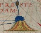
but it actually represents the source of the Nile River:
which I thought was interesting because there is speculation about whether the wavy shapes inside the VMS “volcano” might represent flames, water, or something else.
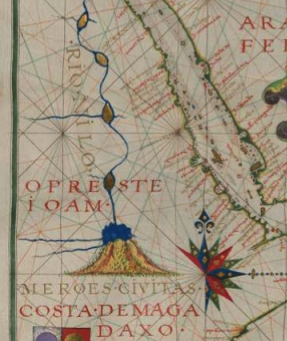
This clip from 1587 is drawn in a similar way (except that the poof is red instead of blue) and represents a volcano in Sicily (in fact volcanic eruptions changed the coastline so dramatically, it’s hard to know what it looked like in the Middle Ages):
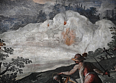
In one version of De Balneis by Petrus de Ebulo (BNF Latin 8161), bathers enjoy the healing waters at the base of a volcano:
(Note the scalloped pattern around the rim of the archway.)
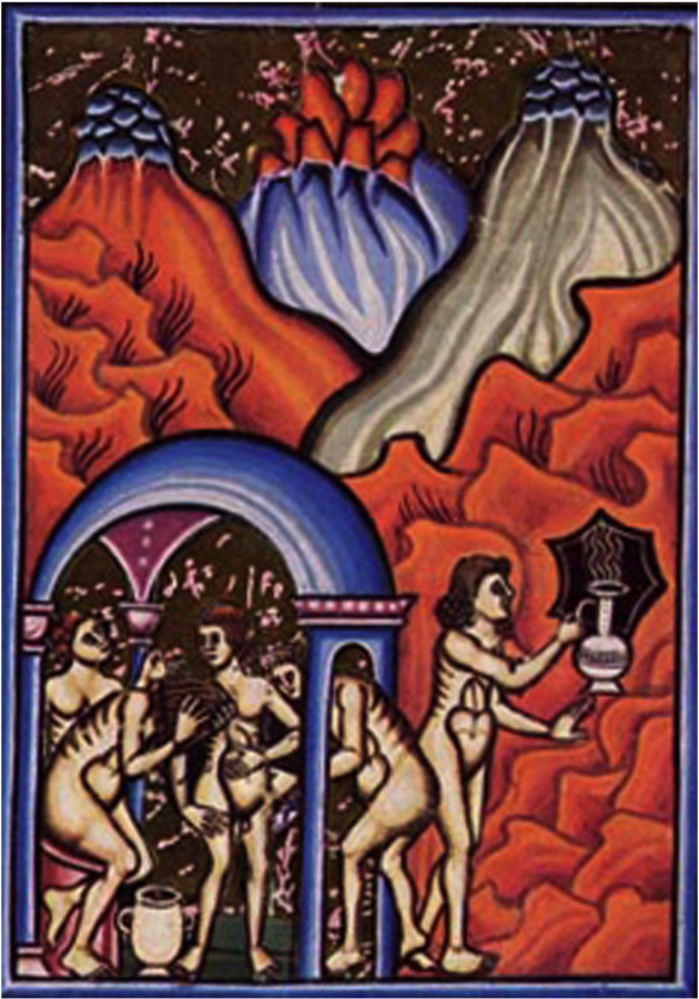
In another version of De Balneis (Angelica) the volcanic activity is more explicit:
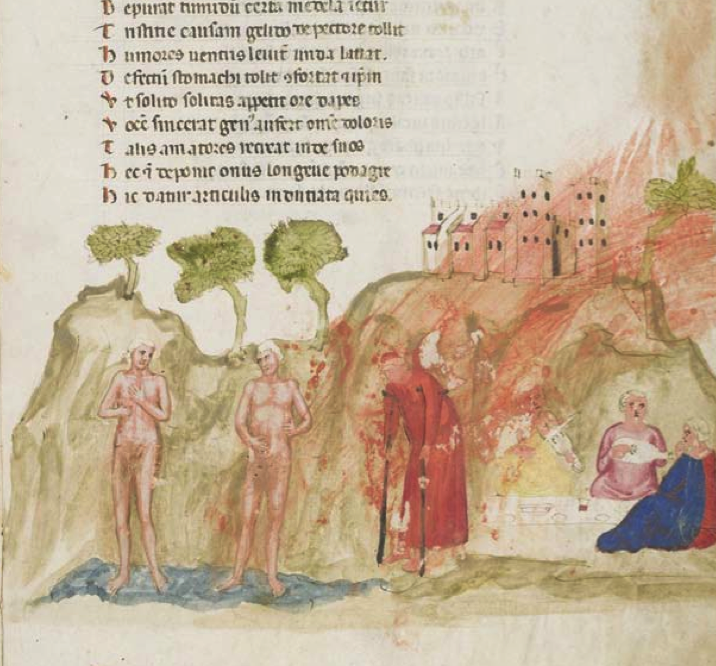
In yet another version of De Balneis (Edinburgh), the fumes are rising on the far right, and radiating as heat (and possibly also as fumes) toward the bathers:
There is a more detailed history of the baths here (which were eventually destroyed by volcanic eruptions):
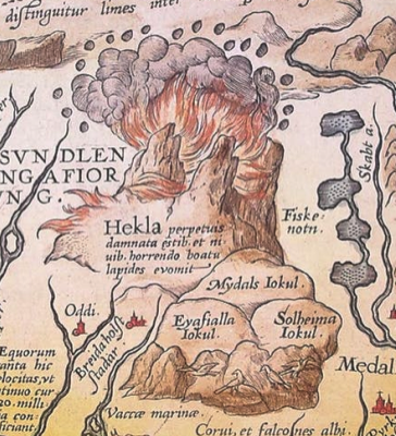
By 1585, depictions of volcanic eruptions were more naturalistic, as in Ortelius’s map of Mt. Hekla erupting in Iceland:
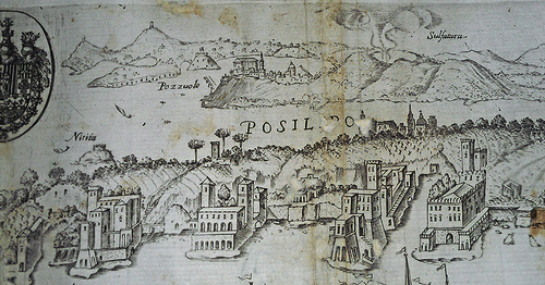
One of the significant thermal sources at Pozzuoli was known as The Solfatar, which was commemorated in a fresco in Rome in the early 1600s:
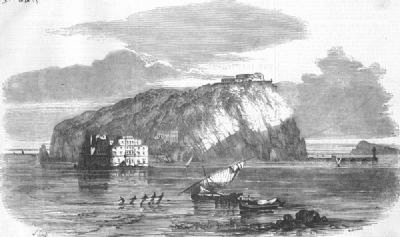
Baratta and Perrey (1680) recorded volcanic activity in Naples in the following engraving, at the site of the former Pozzuoli baths and the island of Nisida.
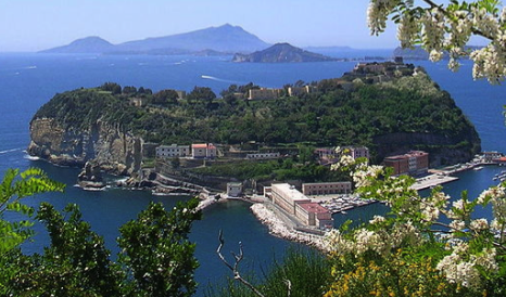
In the past, I have suggested Nisida as a possible source for the top-right VMS rotum. I have numerous ideas for this rotum, but the island of Nisida is on my Top-5 list because it matches several of the topological features of the VMS “map”.
Nisida is shaped like a horseshoe, with a “bowl” of seawater facing deeper water, and may have been connected to the mainland by a stone jetty as it is today. Sea levels were lower in the early Middle Ages and apparently rose again a couple of centuries before the eruption of Monte Nuovo in 1538.
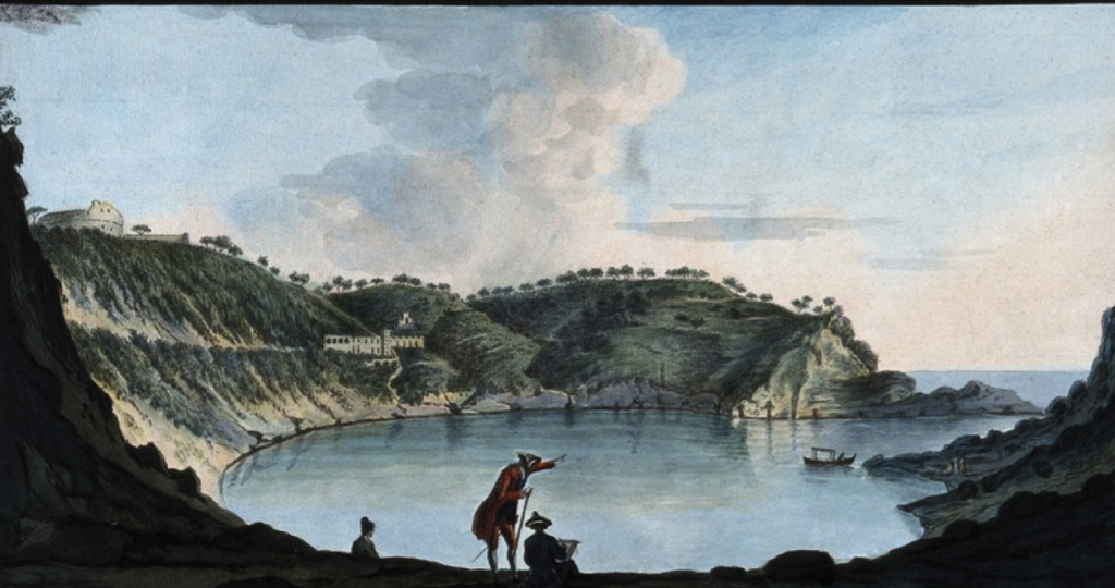
Here is a 1776 view of the Nisida crater, which formed a small harbor:
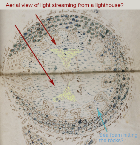
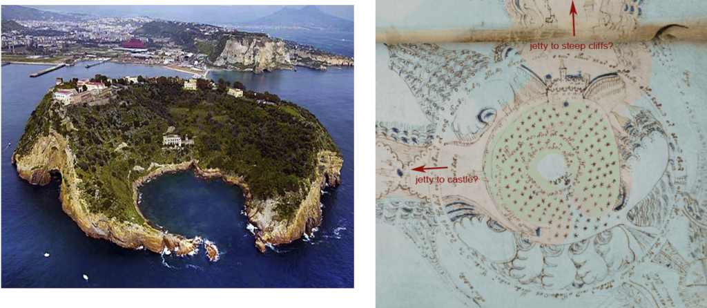
Note in the Baratta/Perrey engraving that there might be a lighthouse on one or more of the outcroppings. Could Rotum6 be an aerial view of a lighthouse with light streaming out from a central column and sea foam lapping against the rocks at the base?:
A 19th-century engraving shows a partly-submerged castle in shallow water near Nisida (perhaps connected to the island by a jetty?). There are also grottoes in the area (the VMS has a number of grotto-like images):
Below is a contemporary view of Nisida from the mainland, showing the white-stone jetty. Note the vantage point for the photo is quite high (there are escarpments in the VMS drawing between Rotum 2 and 3 that might correspond to cliffs).
It is a volcanically active area with many hilly craters and thermal vents. The horseshoe part of Nisida juts out to sea and is battered by rougher water when it’s stormy. There are castle ruins and traces of an old wall in the aerial photos.
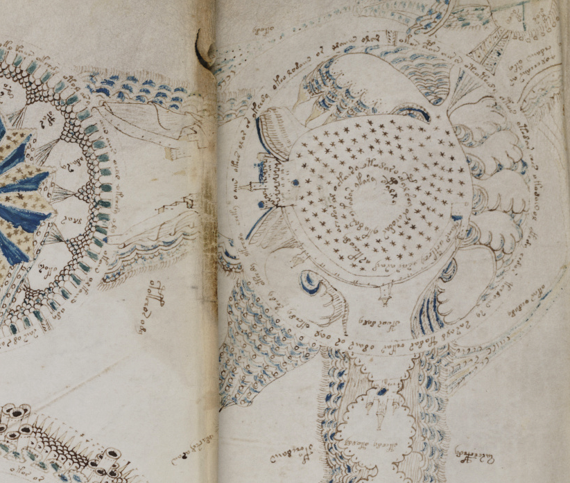
Could the “channels” between the rota be jetties? Erosion and several changes in sea levels have probably increased the size of the hole in the center, but I don’t know how much this has changed since the 15th century.
Other Possibilities
I have much more information on a possible connection to Naples, but what if it’s not a volcano? With the VMS, there are always other possibilities…
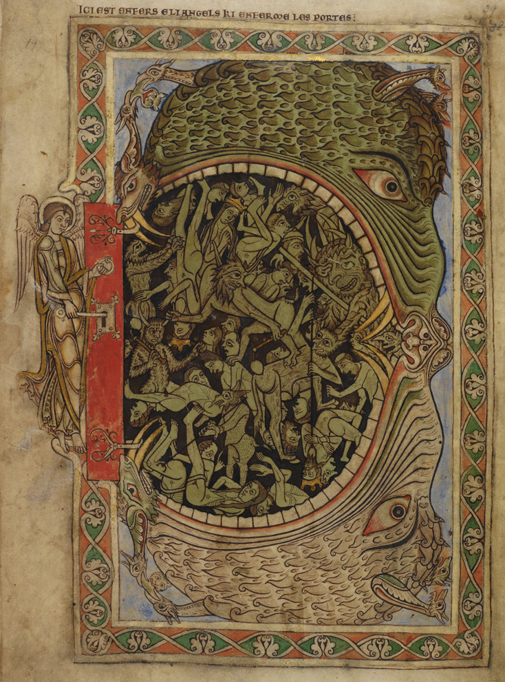
As I’ve written previously, the “volcano” in the VMS could be interpreted in many ways—as a volcano, or the biblical Mount of Olives, a coliseum flooded for water sports (which apparently were quite popular), a famous hill (e.g., the hills of Rome), a hell mouth (I think I heard the hellmouth idea from Ellie Velinska), the New Jerusalem (or some other metaphorical location or description of elemental order), the real Jerusalem, the Baths of Pozzuoli (Campi Flegrei or the sulphur craters), and a few others.
Usually a hellmouth was drawn as a dragon, whale, or crocodile with a toothy, gaping maw, as in this example from the Winchester Psalter (c. 1150):
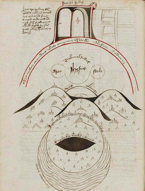
but not always. Here is a schematic representation from the Huntington Library (Germany, c. 1487) that is reminiscent of the eye-shaped rotum in the VMS map (there are even round protrusions on the top-right of the doorway):
Original Ideas
K. Gheuens offered a provocative parallel to the eye-specked fringe of a mollusc. This is one of my favorites, since there are VMS plants suggestive of sea life, including roots that resemble crab, jellyfish, and octopus. Even if none of the imagery turns out to be sea life, the organic shapes give the feeling the illustrator might have lived near the coast for some part of his or her life.
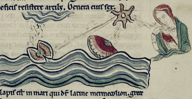
Speaking of sea creatures, this drawing in Bodley 602 has a scallop-like critter that resembles some of the “umbrellas” and other textural motifs in the VMS:
If Rotum 1 really is a volcano, then I think locations like Naples and Sicily deserve serious consideration. If not, then there are many possibilities, maybe even some that haven’t yet been suggested.
J.K. Petersen
© Copyright Jan. 2019 All Rights Reserved
Postscript Feb. 23, 2019:
I planned to post this image of Vesuvius in this blog, but I couldn’t find my link. Then I remembered I had posted it on the Voynich.ninja forum in September 2018, along with some images of volcanoes in Sicily, and other structures (like coliseums) that are large and eye-shaped. It is a re-creation published in Popular Science Monthly in 1906 of what Vesuvius may have looked like in the Middle Ages before the significant eruption of 1631:

Vesuvius was the first volcano I looked at (because the crater is eye-shaped), but I soon realized there are many craters around Napoli that might qualify as a VMS “volcano”, and there are other regions with volcanoes that somewhat match the topology in the VMS rota.
It occurred to me when I first noticed the “pipes” on the rosette foldout, that they might be Medieval or Roman aqueducts, or perhaps “soffioni” (hot steam jets) that occur naturally (or might have been installed) in some of these thermally active areas.
Steam vents sometimes had spiritual significance. Lewis R. Freeman reported in Popular Mechanics that the Romans erected an oracle (and later a spa) at the steam vents of Larderello, near Volterra, Tuscany (look up Priest Consulting Oracle in the Museo Guarnacci Volterra to see a frieze). Could the temple-like dome in the central rotum be an oracle or later spiritual center? Even after Europe was Christianized, many of the Pagan oracle locations were retained as religious sites.
The Romans also built a coliseum in Volterra and, right next to it, a bath complex. Volterra was under Florentine rule in the 15th century and now is a major geothermal engineering center.
Hi JKP,
great post! It’s hard to find medieval images of volcanoes, which I find surprising considering there are several which were active in Italy during that period…
Your idea about the hellmouth is also actually not incompatible with the volcano: several volcanoes and volcanic areas such as Vulcano in the Aeolian Islands, or the volcanic lake Averno (near Naples) to name a few, were known and still are referred to as gates to hell/ hades.
Also FYI the scallop-like critter in the last image is an oyster, and the image represents the formation of pearls. I discussed it in relation to the umbrella-shapes back on the forum in this old thread:
https://www.voynich.ninja/thread-519.html
Hi there,
I enjoyed your volcano comparisons. I think there are quite a few references in the manuscript, actually.
Your mountains of the moon example from the Portolan map may yet be a volcano since some place them at Mount Kilimanjaro. In any event they would exist near the East African Rift.
Thanks for the Huntington one, interesting stuff in the rest of that manuscript too. Do you know if it is showing a particular volcano? I can’t read it and the description doesn’t explain specifically.
I have always taken the volcano in the TO rosette to stand in for Italy when looking at the rosette as Europe, ie the part that sticks out, like the boot does. I always thought of it as Vesuvius. But you are right, it could be Etna.
I never considered the left top rosette as a volcano but i accept it completely now that you have presented it as such. I see it as Ceuta, which has underwater volcanic activity in the general location of the guns, which i take to signify Portugal’s capture thereof. But the Atlas mountains also contain old volcanos, so the rosette could also be thought of as Morocco. I had always thought it indicated a barren area, and i thought maybe the crescents were linked with Berbers, on the Catalan Atlas there are a bunch of tents with this symbol at the top of each. I like the hellmouth idea too. Would there be any link with the volcano idea and the flower that resembles this rosette? I had thought of it as Celosia cristata, upside down the flower kind of resembles a volcano, especially a red one. The scallopped designs here mean mountains to me, which is appropriate anywhere you may place it.
Funny you should mention the scallopped umbrella design, because i think those designs in the manuscript are also volcanos, along with various other representations.
Cheers
JKP – a couple of historical notes, following from LInda’s comment.
As far as I recall we are all indebted to Rich Santacoloma who contributed the result of his own time and research when he introduced the ‘volcano’ idea about… oh, I suppose six years ago or so. Everyone repeats his work; most people fail to mention whose work it is.
It was my own work which provided for what had been called the ‘Nine Rosettes Page’ a full , detailed analytical study identifying not only the correct orientation for it, but detailed description of the routes, landforms, centres of occupation, explanation for the abstract motifs – with historical and cultural notes – which proved that the sheet was a map whose extent was exactly that of contemporary (to 1330) diplomatic and trading ties between three specific partners. Since it represented a couple of months’ labour, I was annoyed to find that while I was on Sabbatical, some charming used-car-salesman had decided to bestow on various friends and acquaintences the brilliant ‘idea’ that folio ‘could be’ a map and that they might like to have a go at the ‘idea’. The various efforts at imitation did nothing for the manuscript’s study but make a total mess, confuse researchers and allow the ‘charming chap’ to pretend that the original study need not be acknowledged.
As far as I recall, the Balneis was contributed to this manuscript’s body of research by someone contributing to a thread begun by Nick Pelling (check his blog).
New work, and solid original research takes time, effort, reading and talent. Donating that to the study surely deserves, at the very least, that no-one else pretend to have done it, even by omission.
Then instead of having to re-work it all, over and over, each person can work at something interesting, new and different.
PS – I don’t agree with Rich’s idea about the volcano.. but read his argument and decide for yourself.
D.N. O’Donovan wrote: “It was my own work which provided for what had been called the ‘Nine Rosettes Page’ a full , detailed analytical study identifying not only the correct orientation for it, but detailed description of the routes, landforms,…”
Good grief. You don’t know if your analysis is CORRECT. It’s meaningless until it is proven.
As for orientation, there are two suns on the folio. It’s OBVIOUS that the two suns MIGHT indicate sunrise and sunset (east and west), or maybe they describe summer and winter solstice. We don’t know yet.
There is also a T-O shape in the upper right, which is a medieval indication of orientation. Are you saying you are the only person on the planet to NOTICE that? That this is some special insight? It’s NOT!
Diane, I am perfectly willing to give credit for insightful research and analysis, but people who whine about not getting credit for things that are obvious need to grow up, stop whining, and just get ON with more research that can prove or DENY the analysis in a more definite way.
D.N. O’Donovan wrote: “As far as I recall we are all indebted to Rich Santacoloma who contributed the result of his own time and research when he introduced the ‘volcano’ idea about… oh, I suppose six years ago or so. Everyone repeats his work; most people fail to mention whose work it is.”
Nonsense. I am not indebted to Rich SantaColoma. I have never read his “volcano” idea. Rotum-1 looked like a volcano to me the first time I saw it (among other things). There are escarpments around it, it’s steep. There are flamey shapes inside it (that might be fire or water). It probably looks like a volcano to MANY people the first time they see it.
If I see an apple and call it an apple, I am not going to hunt for the first person to call an apple an apple and cite them every time I eat one.
It’s ridiculous to “give credit” to someone who is stating the obvious. Do we have to cite the first person to say the VMS plants look like plants?
.
My point in this blog is not to say it’s a volcano (I made other suggestions as well). The POINT is that IF it is a volcano, then topologically (and thematically), it fits quite well with some of the geological (and cultural) structures found in Naples (and possibly also Sicily).
There is some scope for confusion here.
The item that Rich Santacoloma highlighted as a volcano is the thing that points from the upper right circle in the rosettes folio to the central circle. In other discussions this has been proposed to be a teepee.
Most people now interested in the Voynich MS grew up with the first set of digital scans made in 2004. In these scans, this item is partly blocked by the fold in the page. (One can check this in the Jason Davies site).
When the 2014 scans came out, this item became fully visible, and in a way it does look like a mountain with an open top emitting ‘fumes’. Thus Rich described it as a volcano.
However, before the availability of the digital scans, there was a thing called the ‘copyflo’, which is a printout of a 1970’s B/W microfilm of the MS. This could be ordered from the Beinecke, and it was the main instrument for people interested in the MS in the 1990’s. I wonder if you have one, JKP. I ditched mine during my latest move. Anyway, in this copyflo, the ‘volcano’ was clearly visible as such, so the ‘revelation’ by Rich some time after 2014 was not a big surprise for some. Of course it was ‘news’ for most of the post-2004 Voynich MS enthousiasts.
René, thank you for clarifying that.
So there are two different parts of the “map” image that have been associated with volcanoes, the top-left rotum (aerial view), and the textured mountainy thing with something coming out of the top, which is attached to the side of the rotum (which I agree could be interpreted as a volcano, fume vent, geyser, or something along those lines).
For anyone who is confused, my comments in this blog were specific to Rotum 1 (as pictured partway through the blog with the pipes coming out at about 2 o’clock).
I haven’t read most of what SantaColoma has written, so I haven’t seen anything about his “volcano idea” and didn’t know that Diane was talking about a different structure than what this blog is about.
.
Rene, in answer to your question, I honestly don’t remember which version of the VMS scans I was using in the beginning. They were low-res, black and white and annoyingly difficult to interpret, so I put most of my attention to the big plants. As soon as better scans came along, I dumped the old ones.
Hi JKP:
“Nonsense. I am not indebted to Rich SantaColoma. I have never read his “volcano” idea. Rotum-1 looked like a volcano to me the first time I saw it (among other things). There are escarpments around it, it’s steep. There are flamey shapes inside it (that might be fire or water). It probably looks like a volcano to MANY people the first time they see it.”
Several mistakes here: First of all, it was a Tim Tattrie who seems to have first mused on a possible “volcano”… not me, in any case… he brought it to my attention about 2012, because a year before he had requested from the Beinecke what might be in the fold of the rosettes… and they came back with an image, which does show something “spewing” from a “volcano-like” mound…
Secondly, that “volcano” which Mr. Tattrie found (he does not say it IS a volcano, only that it looks like one), and showed me… which I shared with the VMs Net and others… is NOT the “upper left rosette”. Maybe someone thinks that is a volcano, that is of course their choice… I just never heard of it being referred to as such…
Thirdly, you don’t show a picture of the Tattrie “Volcano” in any case. You show the old image of the rosettes, which does not show the contents of the fold, nor the image with started the whole volcano discussion in the first place… Here is a link to the actual volcano image, on my blog post on the subject, which started all this…
https://proto57.wordpress.com/2012/04/21/a-volcano-in-the-voynich/
By the way, my “take” on the lighthouse rosette you show is that it is a fountain, spewing into a pool.
Keep up the good work,
Rich.
Rich, for the rotum on the middle-right that you mention, I like the idea of a fountain. The VMS is full of water imagery, so a fountain would be completely in keeping.
I considered that the middle-top and middle-bottom might be fountains (aerial view) or water wheels (the middle-top reminds me of a cistern/fountain with spouts arranged around the perimeter). I’m not certain, they might also be cosmological rather than literal, but if there are fountains on the “map” page in one form or another, I will not be surprised.
And here is a copy of the (Tim Tattrie requested) image of the unfolded rosettes page, showing the mysterious thingie:
https://proto57.files.wordpress.com/2012/04/86v_detail.jpg
Yes, just read all the comments, and saw René also clarified this issue… but again, it was brought to my attention, not an original find, nor identification, of mine.
As for what I think it may be: http://www.santa-coloma.net/voynich_drebbel/general/hogg_compare.jpg
… this, because it has long been noted (from before we all were born), and I agree, that many images from the Voynich resemble microscopic organisms, plants, and anatomical features, and I have speculatively identified the sources of many as coming from three specific books on microscopy.
I believe the attempt on the rosettes pages is to display the aerial scenery as the macrocosm, and that the rosettes, individually, reflect various “wheel” illustrations found elsewhere in the Voynich… the lower left resembles the “farm” scene, with the pickers; the lower right resembles the “fountain” wheel, and so on. A couple are missing, but several match pretty well. But the lower left “farm” matches closely this microscopic wheat stem image, which has farmers in it (macrocosm/microcosm… farm overhead, wheat stem structure, below): http://www.santa-coloma.net/voynich_drebbel/general/wheat_with_overlay.jpg
Here is another microscopic comparison from Hogg: http://www.santa-coloma.net/voynich_drebbel/general/f39r_screw_moss_1869_hogg.jpg
… and so on. But to this point: I do think the “underfold image” of the rosettes page may be to represent a macrocosmic image of a land feature, and show its similarity to a microcosmic image, the organism, by drawing it the same.
Anyway, that’s my take… your mileage may vary.
Thanks,
Rich.
Rich, thank you for the links. It helps to bring some clarity to the VMS discussion-history.