20 May 2019
I am fond of pyrotechnics and once kayaked out to see a giant fireworks display raining flames on the water.
It was risky. Powerboats with drunk pilots whooshed around me in the dark. To add to the adrenaline, sparks were landing on my shoulders and pfushed and sizzled against the kayak. They could have ignited my clothing or hair… but I loved the front-row seat.
If you can’t resist fireworks, imagine squinting into the middle of a diamond-studded vortex, sparks exploding all around you, with 8-foot swells lifting the boat closer to the blast. It’s awesome.
So it’s natural for me to want to find volcanoes in the VMS “map”. I’ve mentioned volcanoes numerous times on my blog and on the forum, have admitted that the Naples area is on my top-5 list of locations for the VMS “map” (it’s not my only idea, but it was the first region I studied in depth after a long investigation of the water-gardens at the villa d’Este). Recently, I wrote in more detail about volcanoes and mud vents.
Historical Precedent
The idea of volcanoes on the “map” foldout is not new. I took it for granted that many people probably saw them as volcanoes. A quick Google search as I was writing this blog brought up volcano references from 1996 and there are surely some older than that, considering there’s more than one rotum that could be interpreted as a volcano.
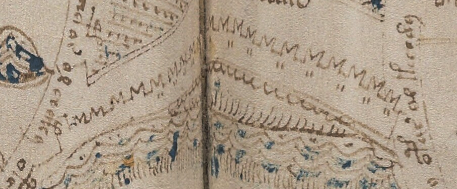
Rotum1 (top-left circle) looks like a mountain or gaping maw. Rotum7 (bottom-left), could be flows of water, but could also be flows of lava.
Similarly there are spewy mounds between the rota that might represent volcanoes or mud vents, but they might also be geysers or natural springs.
I’ve suggested Rotum3 might be the remains of a volcanic crater (e.g., the island of Nisida, which has a small crater-shaped harbor facing the sea, with remains of an ancient castle wall on the ridge).
I’ve also mentioned Vesuvius, the island of Sicily, and volcanic areas around Damascus, Azerbaijan, and the region around Ischia. Even though there are numerous possibilities, Naples is one of my favorites because it has ancient pools that potentially connect volcanic “hot spots” with thermal bathing.
Eruptions in the 14th and 15th Centuries
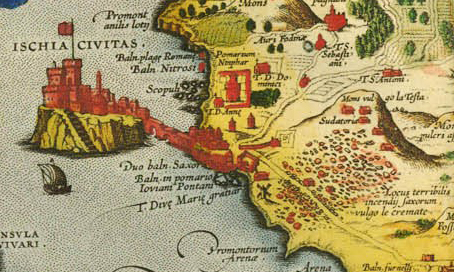
In 1302, there was a “spatter cone” eruption on Ischia (you can see a debris field to the lower right on this old map labeled “Locus terribilis…”):
In 1329, 1333, and 1381 Abraham Rees describes major eruptions of Mt. Etna. These kinds of events could have been handed down as oral or written history to the creator of the Voynich Manuscript. But are they reflected in the VMS “map”?
Cheshire One More Time (and Hopefully the Last)
Gerard Cheshire has based his entire “proto-Romance” linguistics solution around this very premise. In his recent paper he claims the VMS “map” documents a heroic rescue from a volcanic eruption.
In the previous two blogs, I commented on the linguistic flaws in his arguments. In this blog, I’ll quickly summarize his historical assertions.
Cheshire contends that nuns in the Castello Aragonese, off Ischia, wrote the VMS, and that the “map” documents the rescue from a 1444 eruption of Vulcano (in the Aeolian islands).
Other than the eruption, these ideas don’t seem to be supported by facts, …
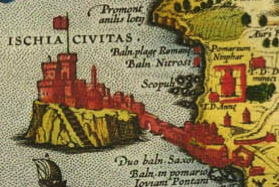
I’ll continue looking, but I haven’t found any evidence that nuns lived on Ischia prior to c. 1600 or that they lived in King Alfonso’s Castello in the 15th century as Cheshire claims. The castle was built in 1441 just off Ischia, as shown in the diagram on the right. Cheshire writes that this is where the VMS originated.
The following timeline shows some key events related to Cheshire’s theory that appear to be at odds with his claims:
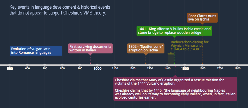
Cheshire says that Maria of Castile organized a rescue from an eruption of Vulcano. The only rescue mission I came across was the liberation of Alfonso and his brother when they were captured in Naples. If any historian has evidence that Maria of Castile ferried victims away from a volcanic eruption in 1444, feel free to comment below.
As much as I like the idea, the interpretation of the VMS map as one or more volcanoes is problematic when applied to the Naples area. There are two sets of Ghibelline merlons on the VMS “map” that don’t mesh well with Naples. In the mid-15th century, this style of battlement was mostly confined to parts of what we now call northern Italy. For this reason, I have never committed fully to Naples and have continued researching the other possibilities on my list…
Lava and Lavage
Let’s assume for a moment that the various vents and flows on the VMS “map” are streams and sources of water, which may or may not have a volcanic source…
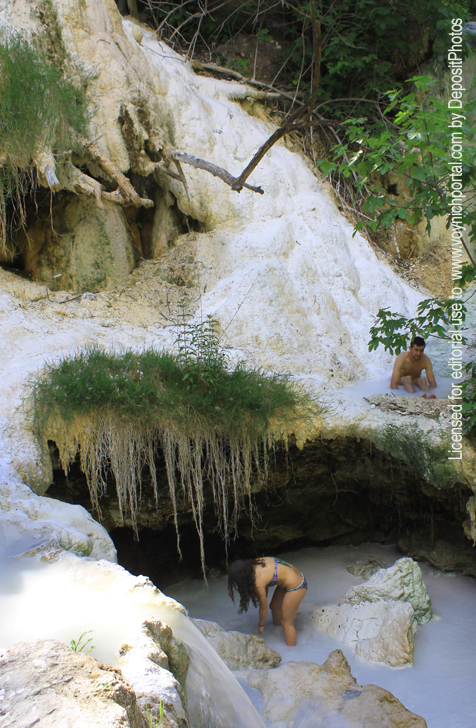
One of my other favored locations is an area with numerous hot springs, including Bagni San Filippo, Bagnore, and Saturnia.
Of particular interest are the natural spring areas of Tuscany, such as San Filippo, where thermal pools, dripping foliage, and calciferous stalactite formations are nestled in a picturesque setting of rivers and woods—just the thing to inspire drawings of nymphly bathing and grotto-like archways and caves.
Some of the pools have calciferous walls that hold the water in step-like terraces. Others are ringed with stone walls that have been built and rebuilt for thousands of years.
Some pools appear bright blue, others green.
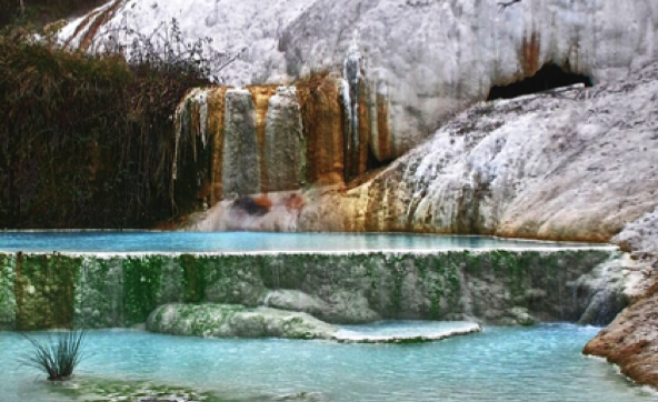
Numerous waterfalls carve pathways through the rocks to feed the step formations:
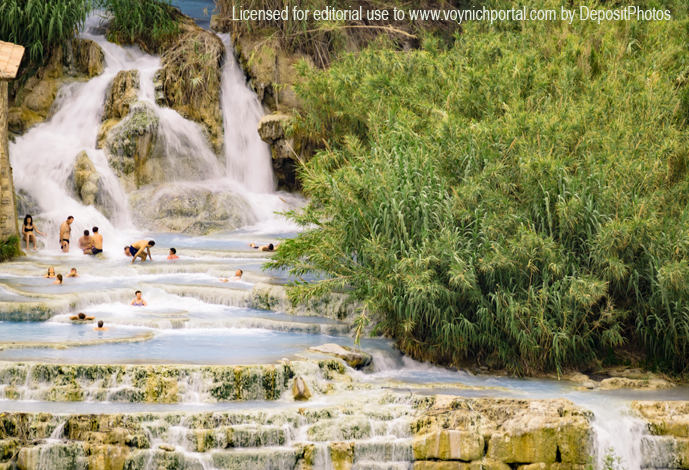
This by itself is not enough to connect San Filippo, Saturnia, or Monticiano hot springs with the VMS. There are thousands of hot springs throughout Europe, in Turkey, Germany, eastern Europe, several regions of Italy, and Sicily.
What interests me about the hot springs in Tuscany is that they are near a stronghold for Ghibelline sympathizers, which might explain the swallowtail merlons:
Some people have suggested that the VMS pools might be color-coded for fresh or salt water. I think this is possible, especially if the pools represent something less literal than bathing pools. But, if they are bathing pools, maybe the colors represent hot or cold water. It was believed (and still is) that alternating between different temperatures can be therapeutic.
It was also believed that pools with certain temperatures and mineral balances were good for particular parts of the body, which might explain some of the drawings in the “bio” section. There’s no guarantee the different sections of the VMS relate to each other, but I’m hoping they do, because a holistic approach, on the part of the designer, appeals to me.
Moon-Shaped Medieval Castles
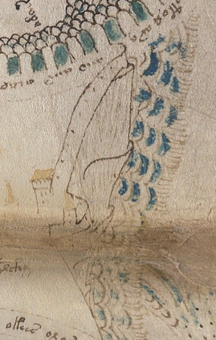
If the “stars” on Rotum3 (upper-right) are meant to represent water, then it’s possible it is a moon-shaped island with a castle at the top. It’s one of the reasons I think it could be an island in the Naples area. There are several crater-shaped islands, including Nisida.
In Greece, Santorini is similar (I’ve been there and if you scramble up Mesa Vuono mountain, you get a real sense of the vastness of the crater).
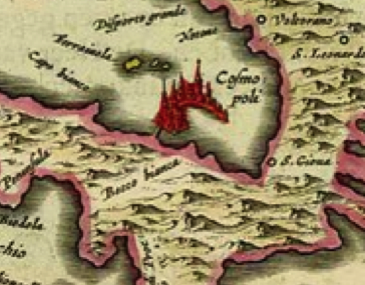
But if the “map” represents Tuscany, where would you find a moon-shaped island? This might be a bit of a stretch, but this 1664 map of Elba, an island off the coast of Tuscany, has a very interesting drawing of a moon-shaped castle-complex labeled Cosmopoli, with a man-made bridge connecting it to Elba. It’s not on a steep hill, like Nisida, but at least it has some of the characteristics of Rotum3:
Rotum3 isn’t necessarily an island, it might just be a stopping point on a strip map, but if it is an island, there are a few locations that could account for its distinctive shape.
Along the Pathway
There’s another detail on the VMS map that can relate to Tuscany… on the pathway between Rotum2 and Rotum3 are some undulating ledges that look somewhat like dunes, possibly sand dunes.
If you turn them, however, so that the tower and wall are facing up, then they look more like solid escarpments.
They’re too steep and narrow to be vineyards, but they reminded me of something, something I couldn’t put my finger on at first…
Then one morning I woke up and remembered—marble quarries, the mountains of Carrara, pathways and ledges.
Here’s a photo…
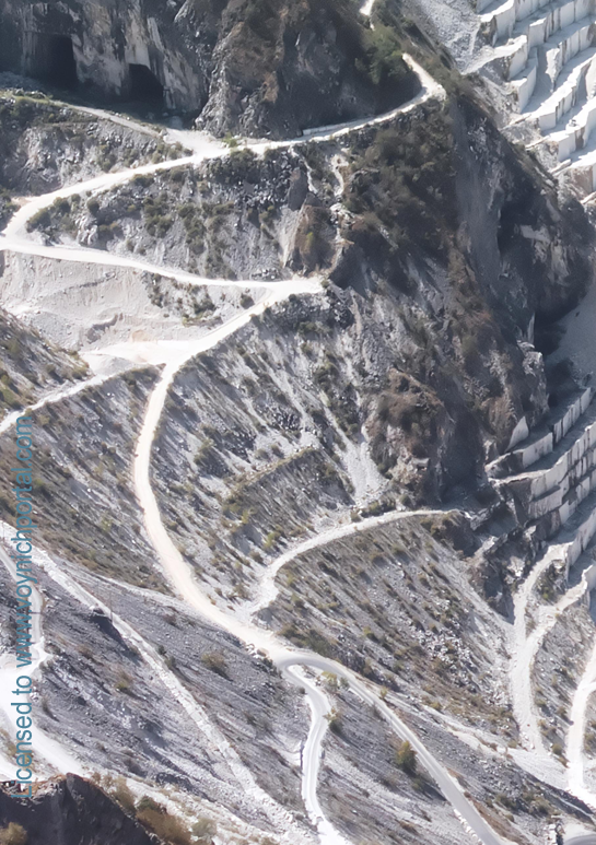
Note the textural differences between the paths winding up into the mountains and the escarpments where the marble has been quarried in stepwise fashion.
We don’t know exactly how the quarry looked in the middle ages, but the mountains have been mined for hundreds of years, supplying marble for pillars, walls, mosaics, and classical statues that grace ancient buildings. Now marble is used largely for floor tiles and countertops.
It’s not a perfect match for the VMS drawing, but it does have a similar feeling, so maybe the “dunes” represent some pathway through mountains.
Summary
I can’t possibly cover every detail of the map in one blog, this is enough for now. Much of this I’ve mentioned before, but it illustrates that there are many ways to interpret the “map”, more of which I’ll cover in future blogs.
J.K. Petersen
© Copyright 2019 J.K. Petersen, All Rights Reserved
> “Some people have suggested that the VMS pools might be color-coded for fresh or salt water.”
Should we be looking to the colors for clues? Weren’t they added significantly later than the text and outlines?
I’m not convinced that the paint was added much later. I do think there were at least two painters, one more careful than the other. Whether they added the paint around the same time, I don’t know.
Based on the plants, I think there was knowledge on the part of at least one painter of what the colors of the plants should be, which would suggest communication or contemporaneous painting by at least one person.
The paint on the faces (cheeks, lips) is very typical for the early and mid-15th century. The palette and some of the animal themes are very similar to some of the Lauber Workshop manuscripts (mid-15th century).
I believe it’s possible that the paint was part of the original conception.
JkP
I’m always interested to learn how an idea first entered the study, and whether (and what) research and explanations were offered with it.
Your search was evidently more fruitful than mine; I couldn’t find any ‘Voynich+volcano’ references from 1996, so I wonder if you could let me have the details of that early item.
I’d also be glad to know if you found any suggestion that the dunes were dunes earlier than I offered it as my opinion of that feature in the context of the map’s analysis. My explanation was more specific, of course, and supported by the usual range of documentation, but if there’s any precedent that I should cite I’m always grateful to know of it and to read what that person had to say, and what evidence they offered.
(Lovely pictures of the volcanic pools in your post).
Volcano reference: Karl Kluge 1996: http://ixoloxi.com/voynich/precednt.html
I haven’t done any searches to see if there are volcano references earlier than that (and I didn’t know about this one until after I began posting the blog). Some of the mountainy shapes and spewy mounds just look like volcanoes to me (or volcanic mud or steam pots).
As for the dunes, they look like dunes to me. I haven’t done any searches whatsoever to see what other researchers might have written about them. But when I turn them the other way so that the tower is facing up, they look like paths and escarpments, so I have to assume they may not dunes.
Thank you for that reference. I’ll be sure to correct any future references of my own; I had thought it introduced by Richard Santacoloma, and more recently.
JKP
correction – Kluge’s reference to volcano just a bit of vague speculation among numerous other ‘silly ideas’ as they are called there. Not an argument and no evidence or effort made to demonstrate the idea’s worth, so I’ll continue to credit Santacoloma who was serious and did offer evidence and argument, though not all was right. But thanks again for responding to the request for sources. Most grateful.
That seems a bit inconsistent to me.
When I blogged about gallows glyphs at the beginnings of paragraphs possibly being pilcrows, you were quick to credit someone who mentioned pilcrows, even though he presented no evidence and did no analysis whatsoever, he simply threw out the idea (and it wasn’t even his idea, according to what you wrote, it was his daughter’s). In contrast, I did quite a bit of analysis and posted statistics (and did not rely in any way on previous speculation).
JKP
I assumed you’d read my analysis of that folio, despite the time over which it was published, since you were already running the present blog. But whatever – there was no earlier effort made to study this folio, just a bit of vague speculation, kite-flying and one accurately observed detail. viz. the rising and the setting sun. No research as such. Researching such a large and difficult drawing isn’t a trivial problem, since not only must each piece be fitted into the overall finding, but in this case it was necessary to distinguish a number of chronological layers, and ascribe each of those, too, to its proper place and time on grounds of style and of content. As I say, not a trivial task and even to list the sources consulted would weary most of my readers. 🙂
About the ‘volcano’ thing. In that case, Credit for first observation and posited identification which I thought due to Rich Santacoloma, he with his usual modesty protests it might be given instead to perhaps it is to be credited to Tim Tattrie.
I intend citing both from hereonin, but here’s the seminal article:
https //proto57.wordpress.com/2012/04/21/a-volcano-in-the-voynich/
I differ from them on the ‘shoulders’ object, but I agree with the other that lies in the western quarter and (as I mentioned at the time) it fits as Stromboli, marker of the entry to the Tyrhennian sea and also as marker between territories of the Italian peninsula and Sicily proper. (can provide references informing those details, too, if you want).
No, Diane, I have not read your analysis of the “map” folio.
I have only seen some of your posts on the Voynich.ninja forum and possibly also on other blogs (like Pelling’s blog) where you mentioned the middle-right rotum being a compass rose and the small tower on the rotum above it being a lighthouse.
Other than that I have no idea what you think about this folio or where we can read your analysis.
Great page…a lot of good work here.
A clarification for the record: As Rich stated, I said it looks like a volcano, not that it was a volcano. It also looks like the Pharos light house (more so in fact with its clear three sections) and matched within the rosette the spiral (Egyptian labyrinth) and yellow cones (granaries/pyramids) and obelisk, and of course the bluish fingers of the delta) etc etc etc. I’ve mentioned this within Rich’s website, or maybe Nicks, or the forum, or maybe just in private correspondence…not sure…it was a long time ago. I never thought for long it was actually a volcano, and if I did I don’t think it’s as important to acknowledge the who, so do not need the credit.
Cheers,
Tim